
Territory and Regions of Peru
Peru is in the central and western part of South America, on the coast of the Pacific Ocean which is its natural border to the west. It also limits with Ecuador and Colombia to the north, with Chile to the south and with Brazil and Bolivia to the east.

It is the third largest country in South America and one of the largest 20 in the world, with a total surface of 1,285.215,6 square kilometers, including its Pacific islands and the Lake Titicaca western islands. This area is larger than the added territories of Spain, France and Germany.
Peru has sovereing right over a territory stretching 200 marine miles off its Pacific shores and is Consulting Party to the Antarctic Treaty, a continent where it has installed the Machu Picchu Scientific Station.
Peru has approximately 27 million inhabitants. The coast shelters 52% of the total population, the highlands 36% and the jungle 12%.
The population is mostly mixed and urban and speaks Spanish, but there are two important minorities: Andean populations, divided in the Quechua and Aymara language families and Amazon populations divided in 14 language families and 42 ethnic groups.
You may also speak English with people working in the tourism industry, like tour guides, travel agency employees, and a staff members at 3 – 5 star hotels.
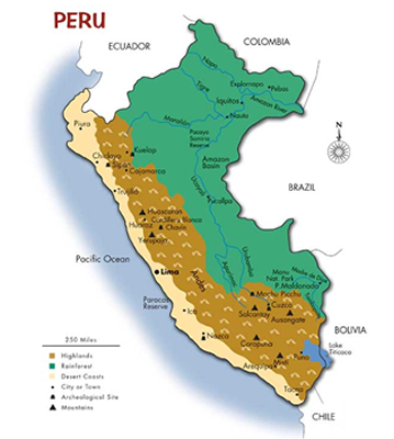
The country comprises three geographic large regions:
Coastline:
11% Territory / 52% Population Close to 1800 miles of deserts, open beaches and fertile valleys.
Highlands:
30% Territory / 36% Population Region dominated by the Andes. The highest point in Peru is the peak of Mount Huascarán (22,204 fasl).
Amazonia:
59% Territory / 12% Population Tropical rainforests of the Peruvian Amazon and region where the largest natural reserves in the country are located.
WEATHER AND RAIN INFORMATION DURING ANY SEASON FOUND AT: www.senamhi.gob.pe
Comment (0)